Committee Meeting 3
July 27, 2021

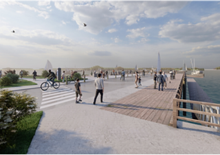
Planning a storm-resilient future for the 2 multi-use piers, nearly 7 acres of park, and more than 1,000 feet of shoreline in the heart of Rockland. This vision, developed in collaboration with a project advisory committee and community input, includes multiple projects that can be implemented.

Both need and opportunity.
The City-owned piers, seawall, and support facilities that Rockland and the region depend on for commercial and recreational harbor access are in serious need of redevelopment. Not only are they well beyond their design lives, they are at the point where repair alone is not enough. The infrastructure is also at risk from storm surges, and redevelopment at higher elevation, and with a more resilient design is necessary to break the cycle of repeat flooding, safety issues, and costly repairs.
Redevelopment for resilience is also an opportunity to include things the community has talked about for years - such as the extension of the Boardwalk, more and better designed green space, terraced seating in the hillside, and better pedestrian connections and ADA accessibility to Downtown.
Why Now?


Project Status
Implementation
First project now funded!
Thanks to support from Maine’s Congressional Delegation and MaineDOT, the City now has secured funding for redevelopment of Middle Pier and Buoy Park. The City will be receiving $4,060,000 in Congressionally-Directed Spending, and $250,000 from MaineDOT’s Small Harbor Improvement Program. The target date for construction to begin is fall of 2026.
The City is working on a funding strategy for the next project on the Downtown Waterfront Harbor Park & the Public Landing.
Permitting
Underway.
Permitting for the Marine infrastructure is underway and is planned to be completed by spring 2024. This will make the project close to "shovel ready," which will be helpful for federal grant applications.
Preliminary Engineering (30%)
Completed.
Preliminary engineering for the marine infrastructure (piers, seawall, and boardwalk) was completed in spring 2023, and preliminary engineering for landside infrastructure was completed in the fall of 2023.
The projects were made possible by two Community Action Grants of $50,000 each.
Conceptual Design and Road Map Completed.
The Conceptual Design balances diverse uses, builds in flexibility, and incorporates ideas from the community and various plans - both past and present. While it was modified in some ways during preliminary engineering in response to stakeholder input and technical design considerations, the project remains close to the original vision.
It was made possible by a $30,000 planning grant from the Maine Coastal Program.
Above: Flooding and storm damage are no longer future risks – they are an all too frequent reality.